Research
Our research encompasses a wide range of study approaches and aquatic environments including streams, floodplains, wetlands, and estuaries. Some of our current and recent research is listed below:
Current Projects
Current Projects
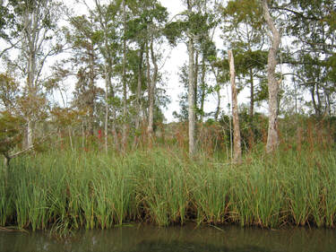
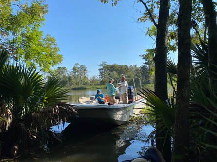
Long-term monitoring and community dynamics associated with tidal freshwater forested wetlands along the lower Apalachicola River
Tidal freshwater forested wetlands (TFFWs) are under increasing scrutiny because of sea level rise and their proximity to oceanic waters. This project will utilize a combination of past data, forest surveys, water measures and remote sensing to examine forest and physio-chemical trends across a tidal gradient. Emphasis of this project will be assessing the risk to TFFWs caused by changes in sea levels and river flows.
(https://www.apalachicolareserve.com/oystercatcher-spring-2022/)
Partners: Florida Department of Environmental Protection, Apalachicola National Estuarine Research Reserve.
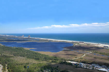
A coupled natural-human framework for risk assessment of coastal communities from land-use and climate change
Forest loss and land conversion may increase discharge, pollutants, and other constituents to coastal waters. This is concerning along the ‘Emerald Coast’ (a region of coastal Alabama and the Florida panhandle) where water clarity is a particularly important for coastal ecosystems and people. This interdisciplinary project will investigate how climate and various socio-economic factors may affect landowner decisions, change forest cover, and impact estuaries along the Gulf of Mexico (GOM). We will utilize landowner surveys, environmental models and stakeholder engagements to estimate future land cover and ultimately water quality to estuaries and their associated communities.
(https://ocm.auburn.edu/newsroom/news_articles/2020/11/120900-nasem-team.php)
Partners: National Academy of Sciences, Engineering and Medicine- Gulf Research Program; University of Georgia; and Dauphin Island Sea Lab/University of South Alabama.
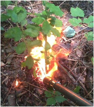
Evaluating fire for the control and restoration of a Chinese privet infested bottomland forest in Alabama
Chinese privet (Ligustrum sinense) is one of the most widely spread and threatening invasive species in the southern U.S. Riparian areas are particularly susceptible to invasion by C. privet due to its regenerative characteristics. Herbicides are commonly used to control C. privet however a potentially useful alternative is fire. A research project to determine the impact of C. privet on bottomland habitats and the efficacy of fire for privet control was initiated along the Black Warrior River near Moundville, AL.
Partners: EBSCO Industries, Inc. (EIC), The Black Warrior Riverkeeper, The Curtis & Edith Munson Foundation, Birmingham Audubon, and the Alabama Invasive Plant Council.
Modeling headwater wetland functions across varying land use
Headwater slope wetlands in the southeast U.S. are typically forested and located at the origin of coastal streams. They are a ubiquitous feature on the coastal plain landscape and valuable for drainage throughout the southeastern U.S. We are assessing the functional attributes of these wetlands (e.g., nutrient cycling, habitat, water storage) across Mobile and Baldwin County, AL and examining their susceptibility to surrounding land use change. Our goal is to spatially model the functional capacity of these important wetlands across the the two county region as part of a larger project to assess coastal Alabama water resources.
Partners: U.S. Department of Treasury- Alabama Center of Excellence
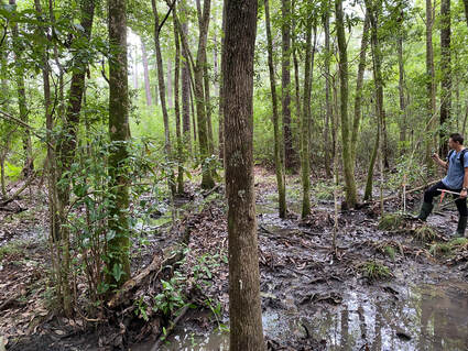
Assessing the function and vulnerability of forested wetlands in the Mobile-Tensaw-Apalachee (MTA) River Delta
The MTA River Delta is approximately 110,000 ha and dominated by a complex of tidal and non-tidal wetlands. We have initiated a study on tidal freshwater forested wetlands within the MTA River Delta. Through a combination of field data collection and modeling, we will characterize wetland hydrology, salinity, and vegetation along a tidal gradient. Further, working with colleagues at Dauphin Island Sea Lab, we will investigate the seasonal contribution of TFFW organic matter to nearby Mobile Bay.
(https://ocm.auburn.edu/newsroom/news_articles/2022/10/050813-forestry-team-researching-delta.php)
Partners: U.S. Department of Treasury- Alabama Center of Excellence, Dauphin Island Sea Lab/University of South Alabama
Recent projects:
The effect of stormwater runoff on salt marsh habitat and resident fish
Shoreline development can alter drainage, increase pollution and fragment habitats. As urban growth continues in coastal areas, it is unclear how much the functional condition of salt marshes may change. We examined how salt marshes and supported resident fish species along the Gulf of Mexico may be influenced by watershed development and changes in stormwater drainage.
Partners: Mississippi-Alabama Sea Grant Consortium, USDA-McIntire Stennis Program, and the Weeks Bay National Estuarine Reserve.
Spatial models for mapping stream head channels
There is significant interest and policy implications associated with the headwater extent of stream channels across the United States. Lab members have been examining the use of topographic data coupled with field data to develop models to locate stream channel heads (the headwater origin of stream channels) across various physiographic regions of Alabama and Michigan.
Partners: Huron Mountain Wildlife Foundation.
Wetland functional response to hydrologic degradation and recovery
From the 1930’s to the early 2000’s the Tampa Bay, FL area depended on groundwater to meet their public water needs. Pumping was significant enough to draw down well field water tables however a new desalinization plant reduced pumping starting in 2008. Using new and historical data, we are examining how well field wetlands have responded to recent hydrologic recovery.
Partners: U.S. Army Corps of Engineers, Tampa Bay Water and the Southwest Florida Water Management District.
Effects of land conversion on coastal headwater wetlands
Along the northern Gulf of Mexico coast, headwater wetlands represent areas of significant exchange between aquatic and terrestrial environments. Our research examined how surrounding land use influences important wetland functions such as the maintenance of water quality, amphibian habitat, hydrology and carbon cycling. Partners: Mississippi-Alabama Sea Grant Consortium, Alabama Agricultural Experiment Station, Week's Bay National Estuarine Research Reserve, and AU Center for Forest Sustainability.
